
Imagine a satellite orbiting 700 kilometers above Earth, quietly capturing images of our planet every few seconds. In a single day, it generates more geographic data than generations of cartographers could process in a lifetime. For decades, this vast information remained largely untouched, stored away in digital archives. Today, artificial intelligence has emerged as a tireless interpreter, capable of uncovering hidden patterns monitoring forests in real time, revealing the subtle dynamics of urban expansion, and detecting environmental changes once obscured by complexity.
This is not science fiction, but the reality of modern geospatial analysis. Trained on millions of images, intelligent systems can now distinguish land-use types, predict disasters such as floods before they occur, and map human settlements in previously unsurveyed regions. The fusion of artificial intelligence and geography has transformed how we see our planet not as a static map, but as a living, evolving system marking a profound shift in the geospatial world
Revolution in Geospatial Data Processing
Every day, satellites orbiting Earth generate terabytes of imagery data of our planet’s surface. This massive volume of data once posed a major challenge for geospatial professionals. How could one possibly manually analyze millions of pixels across thousands of satellite images? This is where artificial intelligence plays a crucial role.
Deep learning algorithms, particularly convolutional neural networks, have revolutionized how we process satellite imagery and aerial photography. These systems can be trained to recognize various geographic objects and phenomena with extraordinary speed and accuracy. An area spanning thousands of square kilometers that once required weeks to map can now be analyzed within hours.
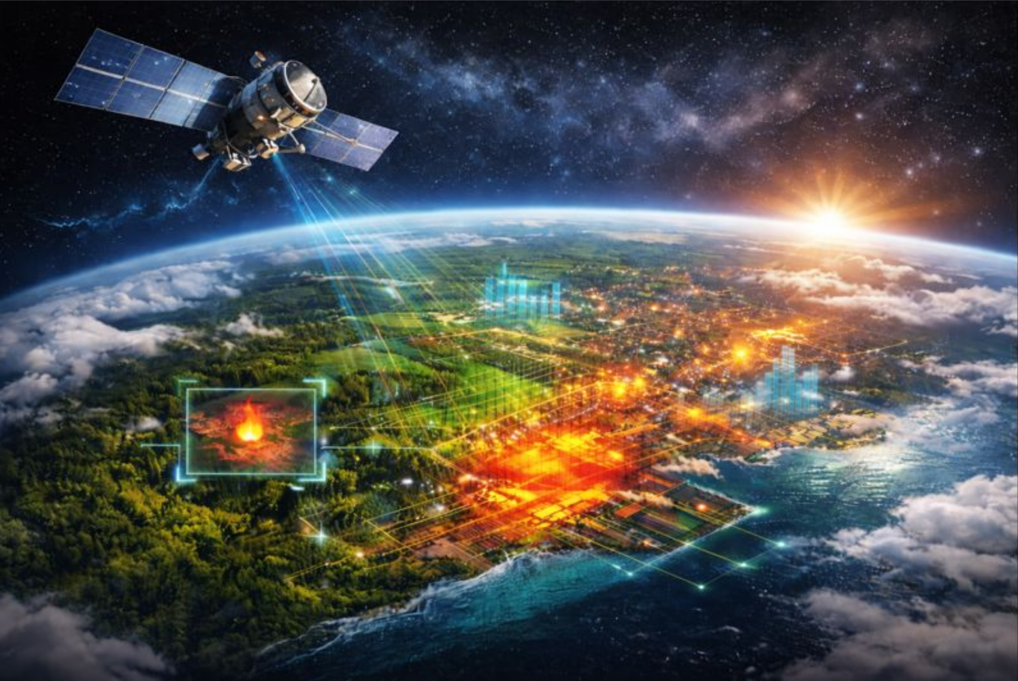
Automatic Land Cover Classification

One of the most impactful applications is automatic land cover classification. AI can distinguish between primary forests, secondary forests, plantations, settlements, agricultural land, and water bodies with impressive detail. More interestingly, these systems not only recognize what exists on the surface but can also detect temporal changes.
Imagine the capability to monitor deforestation across Kalimantan in real-time, or track settlement expansion around conservation areas. This information is invaluable for governments, environmental organizations, and researchers in making timely data-driven decisions.
Predictive Analytics for Regional Planning
Artificial intelligence elevates geospatial analysis to a predictive level. Machine learning can study urban growth patterns from decades of historical data, then project how a city will develop. These models consider various factors such as population growth, economic development, spatial planning policies, and infrastructure accessibility.
These predictive results help urban planners anticipate future needs. Where should new toll roads be built? Which areas need to be prioritized for public transportation development? How can we ensure equitable distribution of healthcare and educational facilities? All these questions can be answered with the help of AI-based predictive analytics.
Anomaly Detection and Environmental Change
AI’s capability in detecting anomalies brings breakthroughs in environmental monitoring. Systems can be trained to recognize normal patterns of an ecosystem, then identify deviations that occur. Illegal mining in protected areas, river pollution, or vegetation pattern changes due to drought can be detected automatically.
In Indonesia, this technology has been used to monitor forest and land fires. Computer vision algorithms analyze multispectral satellite imagery to detect hotspots and smoke even before fires become large. This early warning system enables much faster response, potentially saving thousands of hectares of forest from destruction.
Automatic Geospatial Feature Extraction
Map digitization has always been time-consuming work. Drawing road lines, building boundaries, or river flows from satellite imagery is a repetitive and exhausting task. Now AI can perform this work with high levels of automation.
Deep learning models trained with millions of examples can automatically identify and extract geographic features. Roads can be traced with high precision, buildings can be accurately delineated, and even individual vegetation such as trees can be counted and their positions mapped. This technology not only saves time but also improves consistency and reduces human error.
Multi-dimensional Spatial Analysis
Artificial intelligence enables analysis that better considers the temporal dimension. Time series analysis on geospatial data can reveal patterns and trends invisible in single snapshot analyses. How do migration patterns change over time? Is there a correlation between climate change and shifts in optimal agricultural zones?
AI models can process data from various sources simultaneously, integrating information from satellite imagery, IoT sensor data, social media, and conventional databases. This multi-source approach provides a more holistic understanding of complex geographic phenomena.
More Accurate Disaster Risk Modeling
In the context of disaster management, AI has significantly improved risk modeling capabilities. Algorithms can analyze complex combinations of topography, geology, hydrology, land use, and weather data to identify disaster-prone areas with high precision.
Flood prediction models, for instance, consider not only rainfall and topography but also land cover changes affecting soil water absorption, urban drainage conditions, and even long-term climate change projections. The more data processed, the more accurate the predictions generated.
Democratization of Geospatial Technology Access
AI development also makes geospatial technology more accessible. Natural language processing-based interfaces allow users to interact with GIS systems without mastering complex query languages. A village head can ask in Indonesian, “Show potential land for organic farming within a ten-kilometer radius with good water access,” and the system will display the results.
Cloud-based platforms powered by AI enable small organizations and local governments to access advanced geospatial analysis capabilities without investing in expensive infrastructure. This opens opportunities for more parties to make spatial data-based decisions.
Implementation Challenges
Despite its tremendous potential, implementing AI in geospatial analysis is not without challenges. Model quality heavily depends on training data. If historical data has bias or is not representative, prediction results will also be biased. In areas with high cloud cover like Indonesia, consistently obtaining good quality satellite imagery remains an obstacle.
There are also questions about model interpretability. When an algorithm recommends an optimal location for building a hospital or school, it is important for decision-makers to understand the reasoning behind the recommendation. Overly complex AI models are sometimes difficult to explain, creating a dilemma between accuracy and transparency.
Privacy and Ethics Aspects
AI’s capability in analyzing high-resolution geospatial data also raises privacy concerns. Technology that can identify objects as small as a few tens of centimeters from satellites has the potential to be used for invasive surveillance. Clear regulatory frameworks are needed to ensure this technology is used ethically and responsibly.
The Future of Geospatial Analysis

Moving forward, we will see deeper convergence between AI and other geospatial technologies. Integration with the Internet of Things will produce richer real-time data. Field sensors, surveillance cameras, and mobile devices will continuously stream geographic information that AI can process to provide actionable intelligence.
Digital twin technology, which creates virtual replicas of cities or regions continuously updated in real-time, will become standard in urban planning. AI will simulate the impact of various policy scenarios, helping decision-makers choose the best option before real-world implementation.
AI-powered augmented reality will change how geospatial professionals work in the field. Imagine surveyors who can see historical data, future projections, and hidden infrastructure information overlaid directly in their view while at a location.
The convergence of artificial intelligence and geospatial analysis is not merely about better efficiency or accuracy. It is about opening new possibilities in understanding and managing our planet. From environmental conservation to sustainable urban planning, from disaster mitigation to logistics optimization, the future of geospatial analysis will be increasingly intelligent, increasingly accessible, and increasingly impactful for all our lives.
Referensi
- Maxwell, A. E., Warner, T. A., & Fang, F. (2018). Implementation of machine-learning classification in remote sensing: an applied review. International Journal of Remote Sensing, 39(9), 2784-2817.
- Ma, L., Liu, Y., Zhang, X., Ye, Y., Yin, G., & Johnson, B. A. (2019). Deep learning in remote sensing applications: A meta-analysis and review. ISPRS Journal of Photogrammetry and Remote Sensing, 152, 166-177.
- Zhu, X. X., Tuia, D., Mou, L., Xia, G. S., Zhang, L., Xu, F., & Fraundorfer, F. (2017). Deep learning in remote sensing: A comprehensive review and list of resources. IEEE Geoscience and Remote Sensing Magazine, 5(4), 8-36.
- Kussul, N., Lavreniuk, M., Skakun, S., & Shelestov, A. (2017). Deep learning classification of land cover and crop types using remote sensing data. IEEE Geoscience and Remote Sensing Letters, 14(5), 778-782.