
That morning, a palm oil plantation manager in Riau stared at his laptop screen in amazement. In less than three hours, drones had surveyed 500 hectares of his plantation, and an AI algorithm had identified 127 trees infected with Ganoderma disease. Each diseased tree was marked with precise GPS coordinates. The field team simply followed the digital map to administer treatment.
Five years ago, the same task would have taken two weeks with a survey team of a dozen people. The results were not as comprehensive. Many diseased trees were missed due to limited human vision and the vast area to be covered. Now, with the combination of AI and geospatial technology, Budi’s plantation operates with unprecedented efficiency.
This is not fiction. It is a reality that is currently occurring on various plantations in Indonesia that have embraced digital transformation. Technology that once seemed expensive and complicated is now increasingly accessible and offers very attractive investment returns
Understanding the Complexity of the Modern Plantation Industry
Indonesia is an agrarian country with plantations on a massive scale. We are talking about 16.7 million hectares of palm oil plantations spread from Sumatra to Papua, 1.24 million hectares of coffee plantations largely managed by smallholder farmers, not to mention millions of hectares of rubber, tea, cocoa, and other commodities. Managing assets of this magnitude using conventional methods is not only inefficient, but also nearly impossible if optimal productivity is to be achieved.
Imagine a plantation manager responsible for 5,000 hectares. How can they know the condition of every tree? Which blocks require more fertilizer? Which areas will be ready for harvest next week? Which trees are beginning to suffer pest infestations before the problem spreads? These questions are critical, because a single wrong decision can translate into losses of hundreds of millions of rupiah.
Traditional methods rely on field surveys conducted by foremen or assistants on a weekly or monthly basis. They walk or ride motorcycles along plantation roads, observe crop conditions, and record their findings. This information is then reported to management for decision-making. The process is slow, limited in coverage, and highly dependent on individual experience and integrity.
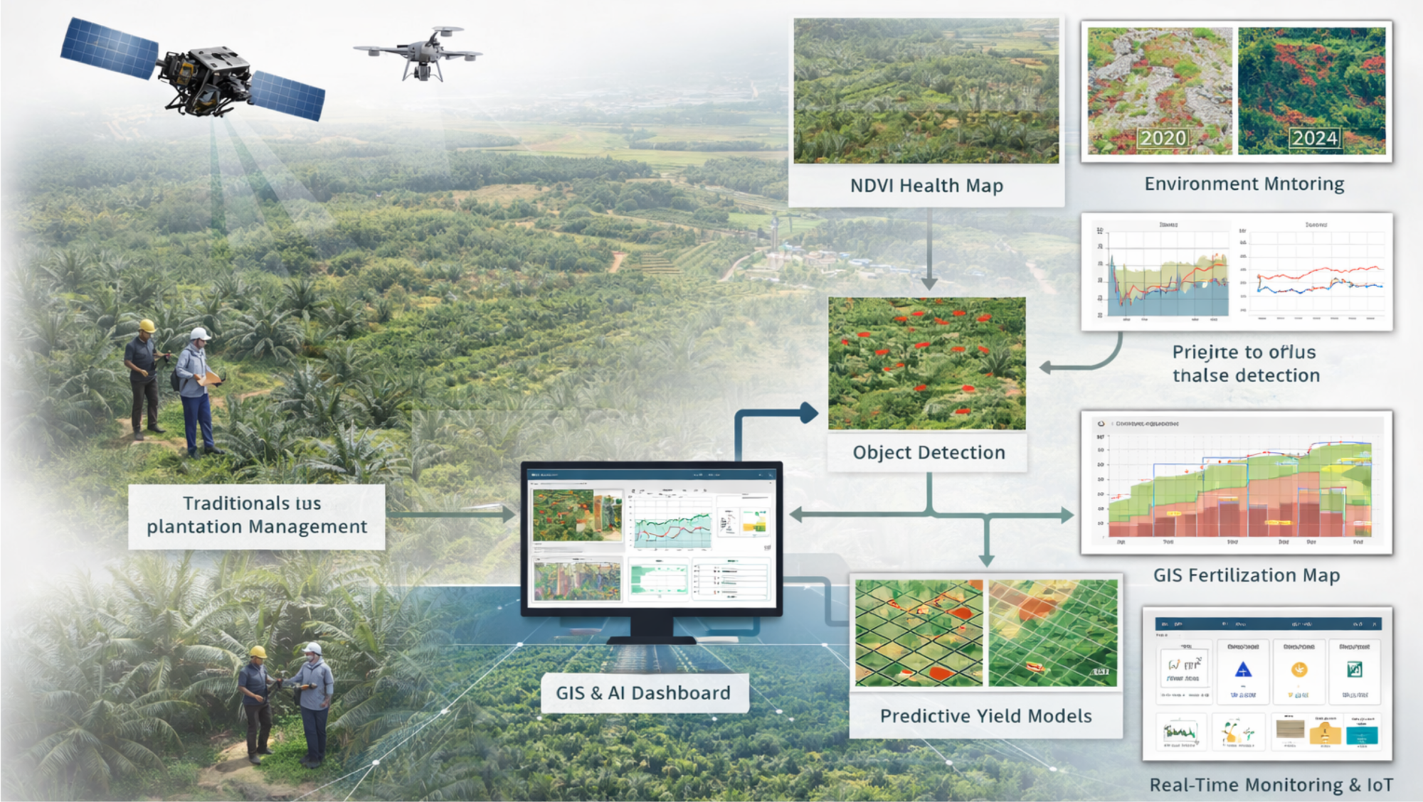
This is where geospatial technology and artificial intelligence fundamentally change the game. With satellite imagery captured every few days, unmanned aerial vehicles that can fly autonomously along preprogrammed coordinates, and algorithms capable of processing millions of pixels in minutes, plantation managers gain full visibility into plantation conditions in real time or near real time.
Seeing Plant Health from the Sky
One of the most powerful applications of this technology is crop health monitoring using vegetation indices. The concept is relatively simple: healthy plants reflect infrared light differently from plants that are stressed or diseased. Using multispectral sensors mounted on drones or satellites, these reflectance patterns can be captured and processed into an index known as NDVI (Normalized Difference Vegetation Index).

When NDVI data is visualized on a map, healthy vegetation appears in dark green, while stressed areas show up in gradients of yellow to red. This map provides a clear, high-level overview of plantation conditions at a glance.
However, the real strength lies not only in visualization, but in the ability of artificial intelligence to interpret the data. Machine learning algorithms are trained on thousands of NDVI samples that have been labeled with actual field conditions. Once trained, AI models can automatically classify every pixel in an image into categories such as healthy, requiring attention, or critical.
At a palm oil plantation in Jambi, the implementation of this system successfully detected a Ganoderma outbreak three months earlier than it would normally be identified through visual inspection. This disease causes fatal basal stem rot in oil palms. Early detection enabled management to implement preventive treatments and quarantine infected areas, saving approximately 2,500 trees and avoiding estimated losses of 750 million rupiah.
What is particularly noteworthy is that the cost of generating these insights is far lower than conventional methods. Manual surveys over such an area would take two weeks and cost around 50 million rupiah. Using drones and artificial intelligence, the process was completed in two days at a total cost of approximately 8 million rupiah, including operations and data processing.
The Right Fertilizer in the Right Place
One of the largest cost components in plantation operations is fertilizer, which can account for 30 to 40 percent of total expenses. Ironically, under conventional practices, fertilizer is often applied uniformly across entire areas without considering the actual variability in soil fertility and plant needs. This represents significant inefficiency and waste.

Precision agriculture technologies fundamentally change this approach. By integrating multispectral imagery, soil fertility maps, and artificial intelligence models, plantations can generate recommendation maps that specify optimal fertilizer dosages for each zone, or even each individual tree. Areas with fertile soil and healthy plants require far less fertilizer than zones with poor soil or stressed crops.
Implementation at a 550-hectare coffee plantation in Lampung produced impressive results. Previously, urea fertilizer was applied uniformly at a rate of 220 kilograms per hectare, consuming a total of 121 tons per season. After adopting variable-rate application based on AI recommendations, total fertilizer usage dropped to 112.1 tons saving 8.9 tons, equivalent to 62 million rupiah per season. The return on investment for this technology was achieved in just 3.5 months.
More important than financial savings is the environmental impact. Excessive fertilizer use leads to runoff that contaminates water sources and increases greenhouse gas emissions. More precise application not only reduces costs but also significantly lowers the environmental footprint of plantation operations
Predicting Harvests with High Accuracy
Accurate yield prediction is a primary objective for plantation management. This information is essential for logistics planning, price negotiations with buyers, labor scheduling, and coordination with processing mills. Yet achieving accurate predictions has always been a major challenge.
Conventional methods rely on visual estimates and experience-based judgments from foremen. Accuracy can deviate by as much as 30 percent, resulting in highly suboptimal planning. Underestimation leads to missed sales opportunities, while overestimation can result in unfulfilled contracts or excess stock that ultimately goes to waste.
Artificial intelligence models transform this process by integrating multiple data sources: NDVI time series from satellite imagery that track crop health over time, historical and forecasted weather data that influence fruit development, information on plant age correlated with productivity, and historical yield records used as training data.
Algorithms such as Random Forest, XGBoost, or LSTM models for time-series data are trained on these historical datasets. Once properly trained, they can predict yields one to three months in advance with significantly higher accuracy.
At a palm oil plantation in Kalimantan, an AI model predicted Fresh Fruit Bunch (FFB) production for March 2024 at 1,850 tons. Actual production reached 1,920 tons, representing an error of only 3.6 percent. This level of accuracy enabled the plantation to optimize buyer contracts, avoid both surplus and shortages, and plan logistics far more efficiently.
Challenges and the Path to Adoption
Despite its clear benefits, digital transformation in the plantation sector is not without challenges. Initial investment costs, particularly for small and medium-sized plantations, can feel substantial. A complete system including drones, analytics software, and management platforms can require an investment of 300 to 500 million rupiah for a 1,000-hectare plantation.
However, ROI calculations show that such investments can pay for themselves within 18 to 24 months through productivity gains and operational efficiency. Moreover, subscription-based and pay-per-use business models are increasingly available, making these technologies more accessible without large upfront capital expenditures.
Another major challenge is workforce readiness. Many plantation workers, especially at the field level, are unfamiliar with digital technologies. The solution lies in structured training programs and user-friendly interfaces. A tea plantation in West Java successfully trained 85 percent of its foremen to use mobile GIS applications within two weeks through phased training and intensive mentoring.
Internet connectivity in remote plantation areas also poses constraints. Nevertheless, many modern solutions are now designed with offline-first capabilities, allowing data to be collected in the field without an internet connection and synchronized later when connectivity becomes available.
Reference
- Sishodia, R. P., Ray, R. L., & Singh, S. K. (2020). Applications of remote sensing in precision agriculture: A review. Remote Sensing, 12(19), 3136.
- Kamilaris, A., & Prenafeta-Boldú, F. X. (2018). Deep learning in agriculture: A survey. Computers and Electronics in Agriculture, 147, 70-90.
- Tsouros, D. C., Bibi, S., & Sarigiannidis, P. G. (2019). A review on UAV-based applications for precision agriculture. Information, 10(11), 349.
- Liakos, K. G., Busato, P., Moshou, D., Pearson, S., & Bochtis, D. (2018). Machine learning in agriculture: A review. Sensors, 18(8), 2674.
- Mahlein, A. K., Kuska, M. T., Behmann, J., Polder, G., & Walter, A. (2018). Hyperspectral sensors and imaging technologies in phytopathology: state of the art. Annual Review of Phytopathology, 56, 535-558.
- Wolfert, S., Ge, L., Verdouw, C., & Bogaardt, M. J. (2017). Big data in smart farming – A review. Agricultural Systems, 153, 69-80.